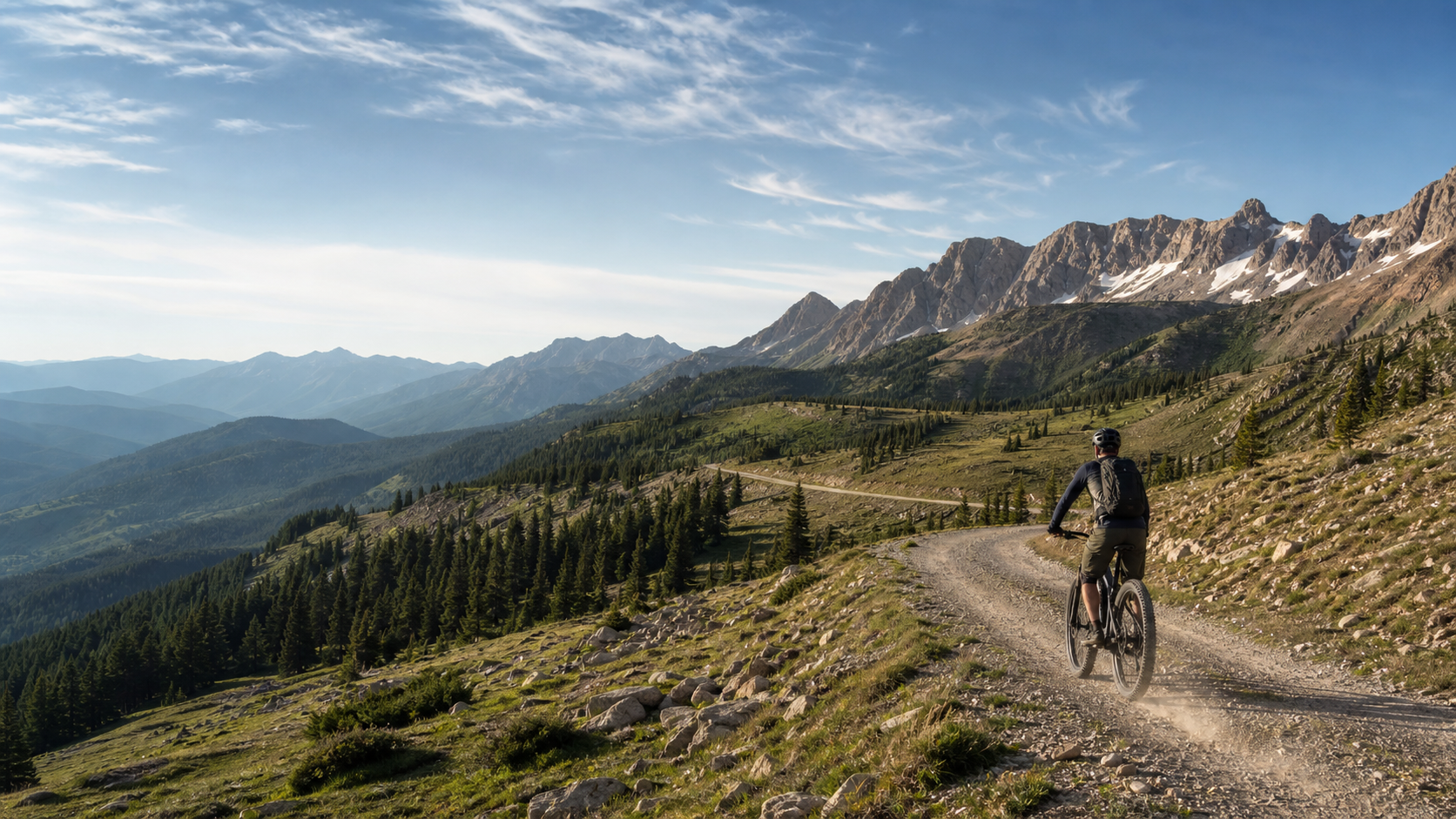
A lone e-bike rider descending a gravel road through high Rocky Mountain terrain

Banff → Antelope Wells · Southbound

The Divide,
with a room key.

A 60-day, hotel-first plan for a Class 1 e-bike—built around real range, real remoteness and the nights when no room exists.

2,681
route miles
52 + 8
ride + rest days
~158k
feet of ascent
45
planned hotel nights
01 The premise

This is not an inn-to-inn route. It is a wilderness route with an unusually good room strategy.

The classic Banff–Antelope Wells line is roughly 2,700 miles of gravel, dirt roads, short trail segments and pavement. Adventure Cycling describes the full route as remote, with more than 200,000 feet of climbing on its current Jasper extension. This plan uses the 2026 Tour Divide track from Banff as a planning spine, then slows it into human-scale stages and adds lodging detours.

The baseline is a fit rider on a legal Class 1 pedal-assist e-MTB, two removable batteries totaling roughly 1,250–1,500 Wh, one compatible fast charger, and camping equipment. Expect 60 calendar days: 52 riding days plus eight planned service/rest days. A mid-July departure is the working target, but snowpack, fire and monsoon timing outrank the calendar.
01

Class 1 is the starting point, not a passport

Land managers set e-bike access segment by segment. Conventional-bike permission does not automatically make a trail legal for an e-bike. The itinerary marks the important verification gates and defaults to motor-vehicle roads when status is unclear.

02

Two batteries are non-negotiable here

Several days exceed 65 rough miles and multiple camps have no power. A single 625–750 Wh pack is not a credible through-route plan. Cold, mud, headwind, weight and climbing can cut optimistic range estimates dramatically.

03

A booked room is not a confirmed charge

Ask the property—in writing—whether two e-bike batteries may be charged in the room or a designated area. Bring a clean fire-resistant charging mat, inspect packs daily and never charge a damaged, wet, hot or unattended battery.

Start window
July 10–25, conditions permitting
Direction
Southbound for the seasonal progression
Calendar
60 planned days + 5 unassigned weather days
Navigation
Current ACA route + addenda + offline backup

The operating rule

Ride the legal line you verified today, not the line a GPX file promised last winter.
02 Route map

A continent in one scroll

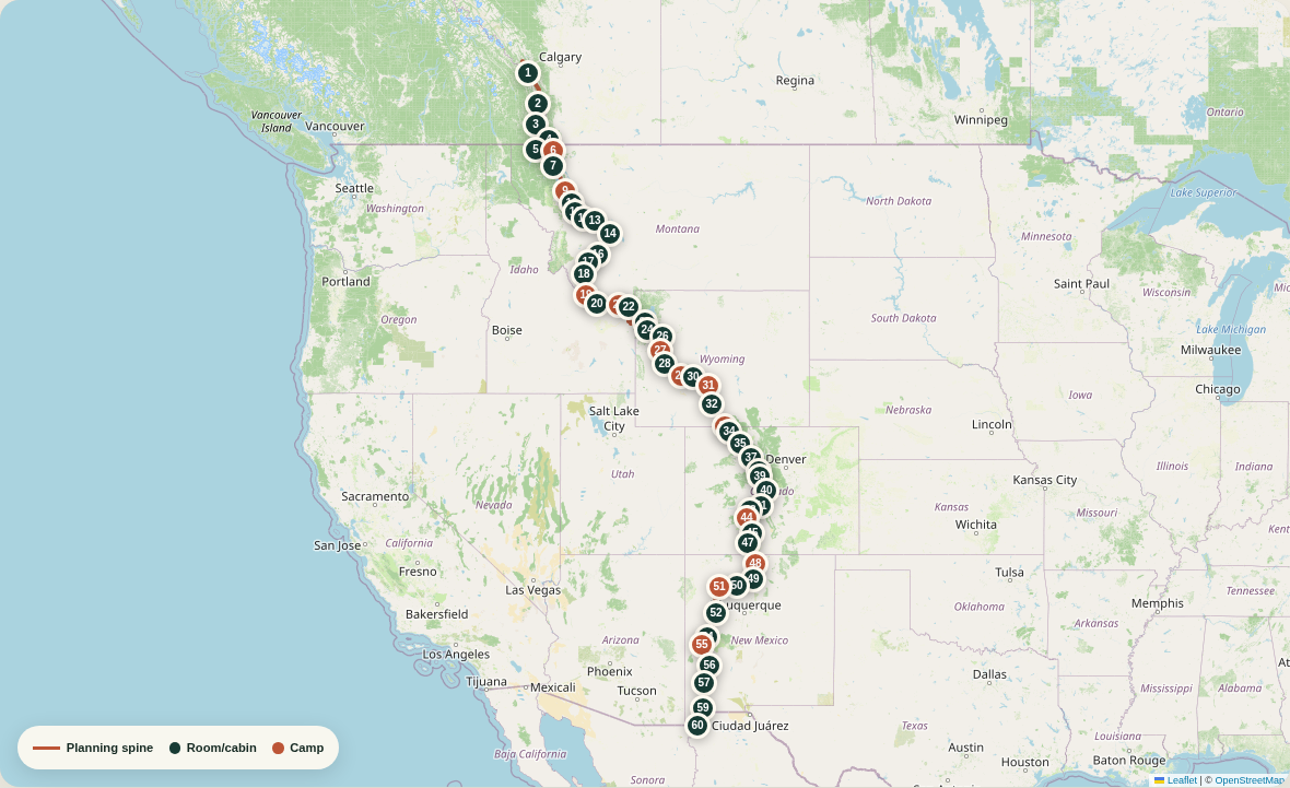
The line is the public 2026 Tour Divide route, simplified for this web map. Markers show planned overnight stops. Use the official Adventure Cycling maps and current addenda for actual navigation.

Static overview map of the 2026 Tour Divide planning spine from Banff to Antelope Wells, with 52 numbered overnight markers colored by room, cabin, or camp
Static route overview · tap to enlarge

Map caveat: Tour Divide and the official GDMBR differ in several places. E-bike bypasses are not drawn as turn-by-turn lines here.

Open the full 2026 route & POIs ↗
60

Days, not deadlines

Fast enough to keep moving. Slow enough to recover.

This cadence averages about 52 miles per riding day. Eight planned rest days sit in towns with bike service, food and room inventory. Weather days should be added on top; never spend your only buffer before New Mexico.

03 Day by day

The full southbound plan

All 60 days are expanded for print and offline saving.

60 days · 52 riding days · 2,707 stage miles including hotel spurs · 2,681 route miles · 45 hotel nights

D01

Banff → Mount Engadine Lodge

Mount Engadine Lodge — reserve far ahead

Room

A deliberately short opening day: Spray River track, Goat Creek and the Smith-Dorrien corridor, with the first sustained gravel climbing and real bear country.

Power: Start at 100%. Confirm a grounded outlet with the lodge in writing.

Canada gate: confirm the exact Class 1 definition and every off-road segment with Parks Canada and Alberta Parks before departure.

31 mi

≈ 4,780 ft gain

Route mi 31

D02

Mount Engadine Lodge → Elkford

Elkford motel room

Room

One of the trip’s first serious tests: Kananaskis gravel, Elk Pass, rougher trail and a long forest-road run into British Columbia. Wet roots and loaded-bike pushing are possible.

Power: Two full batteries. Ask at Boulton Creek about a midday top-up; never count on it without permission.

Access gate: verify Elk Pass/High Rockies routing for pedal-assist bikes; take the current legal road bypass if any trail segment is closed.

68 mi

≈ 5,850 ft gain

Route mi 99

D03

Elkford → Fernie

Fernie hotel or inn

Room

A high-gain day through the Elk Valley: rolling rail-trail pieces, loose forest roads and fast descents. Fernie is the first full-service reset with bike shops and abundant food.

Power: Full overnight charge in Elkford; carry battery two and keep assist low on the climbs.

56 mi

≈ 6,870 ft gain

Route mi 155

D04

Fernie → Butts Cabin

Primitive cabin or legal camp — no guaranteed outlet

Cabin / indoor

The route leaves comfort abruptly for the remote Flathead. Expect logging-road washboard, creek crossings, no reliable services and wildlife-rich country.

Power: Depart with both batteries full. Save at least 45% of battery two for tomorrow.

48 mi

≈ 4,050 ft gain

Route mi 203

D05

Butts Cabin → Eureka

Eureka motel — small inventory, reserve

Room

A long, committing forest day through the Wigwam/Flathead corridor, then the Roosville border crossing and a welcome roll into Eureka. Carry your passport where it stays dry.

Power: Begin on the saved battery, then switch. No dependable charging before Eureka.

Border gate: check Roosville hours and entry requirements shortly before the ride.

71 mi

≈ 6,160 ft gain

Route mi 273

D06

Eureka → Red Meadow Lake

Red Meadow Lake area — legal campsite/cabin only

Camp

Pine forest, quiet dirt and a high-country lake finish. Road conditions can swing from hero gravel to ruts after storms; this is an intentionally conservative no-power night.

Power: Two full batteries; no planned outlet tonight. Finish with one battery substantially reserved.

47 mi

≈ 3,570 ft gain

Route mi 321

D07

Red Meadow Lake → Whitefish

Whitefish hotel — book the rest-day night too

Room

A scenic descent from the Whitefish Range followed by increasingly settled roads. Traffic rises near town, but so do the rewards: laundry, a bike shop and a proper meal.

Power: Use the reserved battery and descend conservatively; full recharge on arrival.

43 mi

≈ 2,590 ft gain

Route mi 363

D08

Rest · Whitefish

Same hotel, second night

Rest day

First service day. Inspect brake pads, tire sealant, drivetrain wear, battery mounts and every rack bolt. Reconfirm the next four stays and buy two days of real food.

0 mi

Planned service day

D09

Whitefish → Cedar Creek Campground

Cedar Creek Campground

Camp

The Swan Valley begins gently, then lengthens into an all-day forest-road ride. Streams are frequent but must be treated; mosquitoes can be relentless at camp.

Power: Two batteries at 100%; this is a long no-outlet day. Run Eco until the final third.

73 mi

≈ 3,970 ft gain

Route mi 436

D10

Cedar Creek Campground → Holland Lake

Holland Lake lodge room if operating; campground fallback

Room

Short on paper, not flat: forested rollers and one more chunk of Swan Valley gravel. The lake is a civilized finish only if the seasonal lodge is actually open.

Power: Use the remaining battery. Lodge outlet and room must be confirmed; carry a campsite reservation as Plan B.

38 mi

≈ 2,930 ft gain

Route mi 474

D11

Holland Lake → Seeley Lake

Seeley Lake motel

Room

A compact, punchy day over forest roads. It is ideal for an unhurried breakfast, a careful descent and an early arrival for supplies.

Power: Full charge if the lodge confirmed power; otherwise use battery two. Recharge in Seeley Lake.

31 mi

≈ 3,310 ft gain

Route mi 504

D12

Seeley Lake → Ovando

Ovando inn or cyclist lodging

Room

A recovery-length stage through the Blackfoot country. Ovando is tiny and famously rider-friendly, but its handful of beds disappear quickly.

Power: One battery is enough in normal conditions; top both batteries overnight.

26 mi

≈ 1,540 ft gain

Route mi 531

D13

Ovando → Lincoln

Lincoln motel

Room

Quiet gravel and timbered ridges lead toward Lincoln. Expect wildlife, cool shaded valleys and short, steep ramps that feel sharper on a loaded e-bike.

Power: Depart full; a single battery may suffice, but carry both.

38 mi

≈ 2,830 ft gain

Route mi 569

D14

Lincoln → Helena

Helena hotel — reserve two nights

Room

A real mountain day over the Continental Divide, followed by technical-feeling loose descents and a final run into Montana’s capital. Heat can build late.

Power: Two full batteries; no assumed mid-route outlet.

61 mi

≈ 5,470 ft gain

Route mi 630

D15

Rest · Helena

Same hotel, second night

Rest day

Full mechanical service: brake-pad thickness, spoke tension, chain wear and charger diagnostics. Repack bear food storage and verify the Helena-to-Butte weather window.

0 mi

Planned service day

D16

Helena → Butte

Butte hotel

Room

The hardest Montana room-to-room stage: multiple passes, rough mining-country roads and more climbing than the mileage suggests. Do not force it in lightning or deep mud.

Power: This is a dual-battery maximum-effort day. Start before sunrise and keep a paved escape option downloaded.

73 mi

≈ 8,020 ft gain

Route mi 703

D17

Butte → Wise River

Wise River lodge/club room; campground fallback

Room

A quieter exit from Butte, forest-road climbing and a long descent into the Big Hole. Washboard and afternoon wind are the usual energy thieves.

Power: Both batteries full. Confirm room, dinner hours and an overnight outlet.

54 mi

≈ 5,130 ft gain

Route mi 757

D18

Wise River → Elkhorn Hot Springs

Elkhorn Hot Springs cabin/room

Room

Pioneer Mountains scenery and a welcome short day. The hot springs are a treat, but this is still a remote seasonal property—confirm meals, room and power.

Power: Easy range day; charge both packs as soon as you check in.

30 mi

≈ 2,510 ft gain

Route mi 787

D19

Elkhorn Hot Springs → Medicine Lodge Creek

Legal creek-side camp

Camp

Big skies replace thick timber. The grade is gentler, but remoteness grows and shade shrinks. Filter water and secure food despite the open landscape.

Power: Two full batteries; preserve battery two for the ride to Lima.

50 mi

≈ 1,430 ft gain

Route mi 838

D20

Medicine Lodge Creek → Lima

Lima motel or cabin

Room

Rolling ranch roads, exposed sun and a gradual return to services. Lima is small, so dinner can vanish when a business closes early.

Power: Use the reserved pack; recharge immediately in Lima.

54 mi

≈ 2,600 ft gain

Route mi 892

D21

Lima → Upper Red Rock Lake

Established campground in the Red Rock Lakes area

Camp

Broad Centennial Valley riding with pronghorn, birds and wind. The low climbing total is deceptive when the road is soft or the headwind settles in.

Power: Leave with two full batteries and budget half the reserve for tomorrow.

56 mi

≈ 1,530 ft gain

Route mi 948

D22

Upper Red Rock Lake → Island Park

Island Park lodge or motel

Room

A short transition into Idaho with volcanic soils, meadow views and the psychological lift of a room, groceries and a hot meal.

Power: Finish on the reserved pack; charge both and confirm tomorrow’s long stage.

29 mi

≈ 1,080 ft gain

Route mi 977

D23

Island Park → Flagg Ranch

Headwaters/Flagg Ranch room or cabin

Room

A long but beautiful rail-trail and forest-road day toward Yellowstone’s southern edge. Sand, washboard and wildlife can slow the first half; traffic grows near the park corridor.

Power: Two full batteries; ask in advance about a permitted lunch-hour top-up. Carry enough capacity to finish without it.

Idaho/Wyoming gate: confirm e-bike access on the rail-trail and every nonmotorized connector; use the signed motor-vehicle-road bypass where required.

86 mi

≈ 4,030 ft gain

Route mi 1,062

D24

Flagg Ranch → Jackson Lake Lodge

Jackson Lake Lodge or Colter Bay cabin

Room

A scenic recovery ride beneath the Tetons. Vehicle traffic and distracted sightseeing drivers are the main hazards, not the grade.

Power: Easy range; recharge on arrival and keep the battery indoors only with property permission.

Grand Teton gate: NPS superintendents control e-bike access. Stay on the currently authorized road/path alignment.

20 mi

≈ 1,040 ft gain

Route mi 1,082

D25

Rest · Jackson Lake / Colter Bay

Same property, second night

Rest day

A genuine scenic rest day. Recheck tire casings and brake pads, restock food for Union Pass country and reconfirm the remote Green River Lakes camp.

0 mi

Planned service day

D26

Jackson Lake Lodge → Lava Mountain Lodge

Lava Mountain Lodge room/cabin

Room

Climb away from the Tetons toward Togwotee Pass, then descend through high forest. Weather changes quickly here; hail and cold rain are plausible even in midsummer.

Power: Both batteries full. Togwotee-area lodges are possible emergency charging stops only with explicit permission.

48 mi

≈ 3,780 ft gain

Route mi 1,129

D27

Lava Mountain Lodge → Green River Lakes

Green River Lakes campground

Camp

A remote passage over Union Pass country with steep, loose pitches and extraordinary Wind River views. Expect slower riding than the mileage implies.

Power: Two full batteries; retain a useful reserve for the easy run to Pinedale.

49 mi

≈ 4,440 ft gain

Route mi 1,179

D28

Green River Lakes → Pinedale

Pinedale hotel

Room

A mostly descending recovery day along the Green River. Pinedale is a major resupply and repair opportunity before the Great Divide Basin.

Power: Use the reserve; recharge both packs and inspect the charging ports for dust.

34 mi

≈ 490 ft gain

Route mi 1,213

D29

Pinedale → Sweetwater River

Legal designated/dispersed site near a verified water source

Camp

Ranchland gives way to sage and historic emigrant-country tracks. Afternoon wind and sandy surfaces matter more than elevation.

Power: Two full batteries; keep the second pack above 50%.

50 mi

≈ 1,800 ft gain

Route mi 1,263

D30

Sweetwater River → Atlantic City

Atlantic City B&B — reservation is essential

Room

Open sage, historic South Pass country and a final climb to the tiny mining settlement. Mud can turn benign roads into drivetrain-eating clay.

Power: Finish on the reserved battery. Confirm room, dinner and outlet; there is no casual backup inventory.

36 mi

≈ 1,790 ft gain

Route mi 1,299

D31

Atlantic City → Great Divide Basin camp

Preselected legal basin camp; no services

Camp

The route commits to the Great Divide Basin: no shade, little water, big wind and immense silence. This camp must be chosen from current land-status and water information.

Power: Two full batteries. No charging; carry the second pack largely unused into camp.

48 mi

≈ 2,270 ft gain

Route mi 1,347

D32

Great Divide Basin camp → Wamsutter

Wamsutter motel

Room

More exposed basin riding and industrial traffic near Wamsutter. The motel and travel stop are functional, not glamorous—and exactly what this section needs.

Power: Run the reserved battery first; a tailwind helps, a headwind can erase the plan.

48 mi

≈ 1,260 ft gain

Route mi 1,395

D33

Wamsutter → Savery / Little Snake River

Confirmed private room if found; otherwise legal river-area camp

Camp

High desert gives way to the Little Snake River country. Expect heat, wind, ranch traffic and a welcome increase in trees near the end.

Power: Both batteries full; no dependable charging between endpoints.

64 mi

≈ 3,140 ft gain

Route mi 1,459

D34

Savery → Brush Mountain Lodge

Brush Mountain Lodge — confirm operating status

Room

Brief but uphill, with enough climbing to prevent calling it a free day. The classic rider lodge is the reward and a useful weather buffer.

Power: Short range day; ask before plugging in and charge both batteries for Steamboat.

17 mi

≈ 1,670 ft gain

Route mi 1,477

D35

Brush Mountain Lodge → Steamboat Springs

Steamboat Springs hotel — reserve two nights

Room

Colorado announces itself with forest climbs, fast gravel and the rewarding drop into Steamboat. Thunderstorms often build after noon.

Power: Two full batteries. The final descent is long; save brakes, not watts.

61 mi

≈ 5,140 ft gain

Route mi 1,538

D36

Rest · Steamboat Springs

Same hotel, second night

Rest day

Major service stop. Replace marginal pads or tires now, refresh tubeless sealant and confirm every Colorado room—summer weekends can be brutally tight.

0 mi

Planned service day

D37

Steamboat Springs → Kremmling

Kremmling motel via planned off-route spur

Room

Lynx Pass, ranch roads and the Colorado River corridor. The room-first detour trades extra pavement for a shower, charging certainty and a safer next stage.

Power: Two full batteries. The Kremmling spur adds roughly 12 miles; navigate it as a deliberate hotel detour.

69 mi

≈ 4,960 ft gain

Route mi 1,595

D38

Kremmling → Silverthorne

Silverthorne hotel

Room

Return to the Divide spine, climb through reservoir country and finish amid Summit County traffic. It is long, high and exposed to lightning.

Power: Both batteries full; this distance includes the return spur to the route. Use Eco until the final Blue River miles.

79 mi

≈ 5,890 ft gain

Route mi 1,662

D39

Silverthorne → Breckenridge

Breckenridge hostel or hotel

Room

A paved-path recovery stage through Frisco and into Breckenridge. Crowds and path etiquette replace wilderness hazards for one afternoon.

Power: A low-demand day on the battery; top up immediately for Boreas Pass.

18 mi

≈ 1,210 ft gain

Route mi 1,679

D40

Breckenridge → Hartsel

Hartsel room/ranch lodging; camping fallback

Room

Boreas Pass is the centerpiece, followed by fast railroad-grade descending and the huge open spaces of South Park.

Power: Two full batteries; do not rely on Como for power.

Colorado gate: the race track can use nonmotorized trail near Breckenridge/Como. Verify Class 1 access and use the all-road Boreas/Como bypass when necessary.

50 mi

≈ 3,270 ft gain

Route mi 1,729

D41

Hartsel → Salida

Salida hotel or hostel — reserve two nights

Room

Rolling South Park roads, one meaningful divide crossing and a long descent toward the Arkansas Valley. Heat rises quickly as elevation drops.

Power: Both batteries full; Hartsel charging must have been confirmed.

48 mi

≈ 2,610 ft gain

Route mi 1,777

D42

Rest · Salida

Same property, second night

Rest day

Last major bike-shop reset before New Mexico. Install fresh sealant for goathead country, inspect battery contacts and buy cold-weather layers if the forecast turns.

0 mi

Planned service day

D43

Salida → Sargents

Sargents cabin/room — confirm seasonal operation

Room

Climb back into high country via Marshall Pass territory. Rocky surfaces and sustained altitude make this harder than the mileage; Sargents is a small, strategic stop.

Power: Both batteries full. Monarch-area grades demand conservative assist.

42 mi

≈ 4,500 ft gain

Route mi 1,819

D44

Sargents → Luder’s Creek

Luder’s Creek Campground

Camp

Cochetopa country: lonely dirt, broad sage parks and fewer services. Treat water and expect frosty air after sunset.

Power: Two full batteries; preserve at least 40% of pack two.

47 mi

≈ 2,790 ft gain

Route mi 1,867

D45

Luder’s Creek → Del Norte

Del Norte inn/hostel — reserve two nights

Room

The route rolls through ranchland, Penitente country and the open valley. Del Norte arrives as a genuine oasis with food, laundry and rider lodging.

Power: Use the reserved pack, keeping enough margin for wind across the San Luis Valley.

63 mi

≈ 3,390 ft gain

Route mi 1,929

D46

Rest · Del Norte

Same property, second night

Rest day

Acclimatize before the route’s highest terrain. Check Indiana Pass weather, brake heat management and the next confirmed outlet in Platoro.

0 mi

Planned service day

D47

Del Norte → Platoro

Platoro lodge/cabin

Room

The queen stage: relentless climbing, Indiana Pass near 11,900 feet and rough mining roads before descending to Platoro. Start at dawn and abandon the high route for lightning.

Power: Dual-battery day with no casual reserve. Lowest assist on every rideable climb.

47 mi

≈ 6,660 ft gain

Route mi 1,977

D48

Platoro → Hopewell Lake

Hopewell Lake Campground

Camp

Another huge alpine day over remote southern Colorado and northern New Mexico roads. Forest clay can become nearly unrideable after rain.

Power: Two full batteries; no planned outlet. Cold, altitude and mud all reduce range.

New Mexico gate: the 2026 race track uses CDT-style trail near Hopewell. Verify access; the e-bike plan defaults to the legal forest-road alignment.

70 mi

≈ 6,860 ft gain

Route mi 2,047

D49

Hopewell Lake → Abiquiu

Abiquiu inn/guest room

Room

Descend from cool forest into red-rock New Mexico. Roads grow drier and rougher; Bode’s is the critical resupply before the next mountain block.

Power: Use the preserved second battery. Confirm the property permits indoor charging.

55 mi

≈ 2,680 ft gain

Route mi 2,102

D50

Abiquiu → Cuba

Cuba motel

Room

Steep, eroded roads climb away from the Chama before a long, remote crossing to Cuba. Heat below and storms above can happen on the same day.

Power: The trip’s hardest battery equation: two full high-capacity packs, low assist, early start and a downloaded paved bailout.

77 mi

≈ 8,770 ft gain

Route mi 2,179

D51

Cuba → Chaco corridor camp

Preselected legal camp near the Chaco corridor

Camp

Exposed mesas, sand and little shade. Mileage can crawl when wet clay or deep sand appears; carry significantly more water than a mountain day.

Power: Two full batteries; preserve more than half of battery two for Grants.

53 mi

≈ 1,130 ft gain

Route mi 2,232

D52

Chaco corridor camp → Grants

Grants hotel — reserve two nights

Room

Long mesa roads and gradual reentry to services. Wind, heat and sticky mud remain the big variables; Grants has the first deep resupply in days.

Power: Use the preserved battery, then recharge both and service the bike.

69 mi

≈ 1,940 ft gain

Route mi 2,301

D53

Rest · Grants

Same hotel, second night

Rest day

Replace worn tires now if needed. Refresh sealant, confirm Pie Town hospitality and check fire restrictions and Gila road status before leaving.

0 mi

Planned service day

D54

Grants → Pie Town

Toaster House or reserved Pie Town room/RV cabin

Cabin / indoor

Lava-country views, high desert and long quiet roads. Pie Town’s hospitality is legendary, but food and beds operate on small-town schedules.

Power: Two full batteries. Ask before charging at any volunteer-run lodging and make a contribution.

68 mi

≈ 2,250 ft gain

Route mi 2,369

D55

Pie Town → Valle Tio Vences

Valle Tio Vences Campground

Camp

A positioning day into the Gila approach. Use the extra afternoon to rest, filter water and prepare for tomorrow’s long no-services crossing.

Power: Short stage by design; arrive with most of battery two untouched.

29 mi

≈ 1,620 ft gain

Route mi 2,398

D56

Valle Tio Vences → Geronimo Trail Guest Ranch

Geronimo Trail Guest Ranch — meal/room/outlet confirmed

Room

Remote ranch roads and a very long Gila day. Grades are modest compared with Colorado, but distance, heat and isolation make this committing.

Power: Begin with both batteries full from Pie Town and the reserve preserved overnight; there is no mid-stage charging plan.

78 mi

≈ 2,410 ft gain

Route mi 2,475

D57

Geronimo Trail Guest Ranch → Silver City

Silver City hotel — reserve two nights

Room

The Gila roller coaster: repeated steep climbs and descents, rough forest roads and a final push through Pinos Altos. This is among the trip’s hardest days.

Power: Maximum dual-battery day. Use the lowest practical assist and take every safe water stop.

68 mi

≈ 8,460 ft gain

Route mi 2,543

D58

Rest · Silver City

Same hotel, second night

Rest day

Final full reset. Fit fresh brake pads if marginal, top sealant, arrange the Antelope Wells pickup in writing and confirm the Hachita overnight.

0 mi

Planned service day

D59

Silver City → Hachita

Hachita Bike Ranch/hostel or confirmed community lodging

Cabin / indoor

A long descent from the mountains, frontage-road riding and a turn south into Chihuahuan Desert scale. Start before heat and wind build.

Power: Two full batteries; most miles are faster, but sand and headwind can consume the reserve.

Silver City gate: verify the current e-bike status of the San Vicente Creek trail exit and use the signed road bypass if it is not authorized.

89 mi

≈ 2,470 ft gain

Route mi 2,632

D60

Hachita → Antelope Wells

Prearranged shuttle to Columbus, Deming or El Paso hotel

Room

The final desert road is stark, exposed and emotionally enormous. Antelope Wells has no celebratory services—your confirmed pickup is part of the route, not an optional extra.

Power: One full battery is normally adequate; carry both because heat and wind rewrite averages.

Finish gate: reconfirm pickup 48 hours out and again from Silver City; carry enough water and shade to wait safely if the vehicle is delayed.

50 mi

≈ 1,600 ft gain

Route mi 2,681

04 Power architecture

Think in watt-hours,
not dashboard miles.

The route punishes optimistic range. Start with a measured consumption number from loaded gravel training, then add a 30% weather-and-surface reserve.

Daily energy estimate

miles × tested Wh/mi × 1.30

68 mi × 16 Wh/mi × 1.30

≈ 1,414 Wh required
1

Leave full

Charge both packs only after they cool and dry. Inspect the case, contacts and mount.

2

Ride boringly

Eco on flats, low cadence protection on climbs, no boost for headwinds you cannot outrun.

3

Switch early

Rotate packs near 20–30%, not at shutdown. A hard cutoff in technical terrain is avoidable.

4

Land with margin

Target 20% remaining at a powered stay and much more before an unpowered camp.

05 Equipment

Carry comfort where it matters.
Carry redundancy where it saves the trip.

This is a hotel-first kit, not a hotel-dependent kit. The sleep system stays aboard because the route contains unavoidable unpowered nights and occasional room failures.

The machine

A serviceable hardtail beats an exotic orphan.

Choose a Class 1 mid-drive e-MTB with a 120 mm fork, conservative 20 mph assist cutoff, readily available drivetrain/brake parts and a dealer network along the Rockies. Avoid proprietary hardware that no small-town shop can diagnose.

Tires29 × 2.25–2.4", reinforced tubeless
Brakes4-piston, 180–203 mm rotors
GearingTrue climbing gear, 30T × 51T class
CapacityTwo packs, 1,250–1,500 Wh total
  • Class 1 compliance label and paper manual
  • Two matched, removable batteries
  • One fast OEM charger + compact spare charger
  • Outlet tester, short 14-gauge extension and 3-way tap
  • Fire-resistant charging mat/bag used open, never sealed while charging
  • Battery contact covers and waterproof transport sleeves
  • Full-size frame lock or robust café lock
  • Spare battery keys carried separately

The workshop

Repair the failures that actually strand a heavy bike.

A 60-pound e-bike is harder on tires, spokes, pads and chains. The kit should cover high-probability mechanicals; motor or battery electronics require a bailout plan and manufacturer support.

Sealant4–6 oz refresh + plugs
Tubes2 correct-size spares
Brake pads2 full spare sets
DrivetrainQuick links + short chain section
  • High-volume mini pump and pressure gauge
  • Tubeless plugs, boot, patches, levers and valve cores
  • Two tubes plus one emergency TPU tube
  • Multi-tool with chain breaker and correct Torx bits
  • Spare derailleur hanger and two quick links
  • FiberFix/emergency spoke and spoke wrench
  • Two pairs of brake pads and rotor truing tool
  • Zip ties, tape, bolts, lube, rag and nitrile gloves

The fallback room

Warm, dry and modest—not ultralight theater.

Expect frost at altitude and desert heat at the finish. The shelter must survive a real storm, and every critical insulation piece should stay dry inside a separate liner.

ShelterFreestanding 3-season tent
Sleep20°F bag/quilt + R4 pad
RainJacket, pants, waterproof mitts
Water4 L north; 6–8 L desert capacity
  • Tent, footprint, stakes and repair sleeve
  • 20°F sleep system and insulated pad
  • Stove, pot, lighter and one cold meal reserve
  • Merino base, active insulation and warm puffy
  • Rain shell, rain pants and waterproof gloves
  • Two riding kits; one never-wet sleep set
  • Filter, chemical backup and desert water bladders
  • Bear-resistant food system appropriate to each jurisdiction

The lifeline

Assume the phone has no bars when the decision matters.

Carry the current ACA route, offline maps, a dedicated GPS and a satellite communicator. The communicator is not a force field: leave a route and check-in plan with a human who knows when to escalate.

Primary navDedicated GPS + current track
BackupPhone offline maps + paper ACA maps
CommsTwo-way satellite messenger
First aidTrauma-aware, personally trained
  • Current ACA maps/digital route and addenda
  • Satellite messenger with active subscription and test
  • Phone maps fully offline; power bank and cables
  • Bear spray bought after air travel and carried accessible
  • First-aid kit, meds, emergency bivy and whistle
  • Front/rear daytime lights and reflective vest
  • Passport, insurance details and emergency contacts
  • Printed bailout, shuttle and manufacturer support numbers

Checklist progress saves only in this browser.

06 Before wheels roll

The final 72-hour gate

Run this again before each multi-day block, not just in Banff.

  1. 01

    Access

    Check the current ACA addenda, relevant motor-vehicle-use maps and each park/forest e-bike rule. Download any legal bypass.

  2. 02

    Fire + weather

    Review NIFC incidents, local closures, pass forecasts, lightning timing, stream levels and New Mexico monsoon risk.

  3. 03

    Rooms + outlets

    Call every small property. Confirm date, late-arrival plan, meals, secure bike storage and permission to charge two batteries.

  4. 04

    Energy

    Recalculate the next stage from your measured Wh/mi, not the manufacturer range screen. Add 30%; add more for cold, mud or headwind.

  5. 05

    Extraction

    Share the live plan and check-in threshold. Reconfirm the Antelope Wells pickup 48 hours out and from Silver City.

07 Sources + scope

Planning aid,
not a purchased route.

Route mileage, ascent and overnight geography are derived from the public 2026 Tour Divide route with POIs. The Tour Divide track is not identical to Adventure Cycling’s official GDMBR. Buy or download the current Adventure Cycling route set and check its updates and corrections before riding.

E-bike access guidance is grounded in Parks Canada’s current restriction language, the NPS e-bike rule, the BLM e-bike FAQ and current Forest Service motor-vehicle-use designations. None creates blanket permission for every trail.

Check the National Interagency Fire Center and local land managers for fire closures. For the southern finish, begin with the Adventure Cycling shuttle list and verify every operator yourself.

Sources rechecked July 30, 2026. Lodging names are candidates, not endorsements or live availability. Distances and gain are planning estimates; weather and reroutes change them.