Washington, DC → Pittsburgh · C&O + GAP
Towpath to Three Rivers
A hotel-first, e-bike-friendly plan for the cleanest trail line from Georgetown to Point State Park: 335-ish miles of canal towpath, railroad grade, river towns, tunnels, viaducts, and one very satisfying skyline finish.
The premise
Skip the highway puzzle. Ride the famous line that already works.
DC to Pittsburgh is one of the best long e-bike trips in the eastern U.S. because it is not a route-finding stunt. The C&O Canal Towpath carries you from Georgetown to Cumberland; the Great Allegheny Passage carries you from Cumberland to Pittsburgh. The hard parts are not “can this connect?” They are weather, surfaces, closures, lodging, charging, and the discipline to keep a vacation from becoming a sufferfest.
Treat “all trail” as conditional
The intended line is trail/towpath end to end, but closures, flood damage, tunnel work, and local detours can change the day. Check official alerts right before departure.
Use Class 1 as the default
A pedal-assist e-bike is the least controversial choice. Verify current rules for the C&O, GAP segments, state parks, towns, and any detour before assuming access.
Plan battery like mud is a headwind
The C&O can be slow, soft, and energy-hungry after rain. A second battery or very conservative assist makes this relaxing instead of math class with mosquitoes.
Static route map
The whole trip in one westbound line
This map is deliberately schematic: use it to understand the trip shape, not to navigate. The real navigation layer should be the current official trail maps, downloaded offline before you leave.

Segment 1
C&O Canal Towpath
Georgetown to Cumberland · 184.5 miles. Flat does not mean easy. Expect packed dirt, crushed stone, roots, puddles, historic lockhouses, river views, and days where rain turns “pedal assist” into “assist the pedals.”
Segment 2
Great Allegheny Passage
Cumberland to Pittsburgh · 150 miles. Crushed-limestone rail-trail, the climb to the Eastern Continental Divide, Big Savage Tunnel seasonality, viaducts, Ohiopyle, Youghiogheny miles, and an urban roll into downtown.
Profile
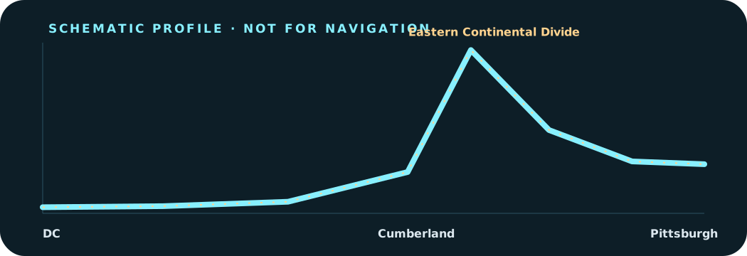
The climb is polite, but it is still a climb.
The C&O trends gently upstream. The GAP does the real lifting from Cumberland to the Eastern Continental Divide, then pays it back with a long railroad-grade descent toward Pittsburgh.
Operating rule
If it rained hard last night, your range estimate is fiction until proven otherwise.
Day by day
The capable e-bike plan
This seven-day version assumes a healthy rider, loaded e-bike, conservative assist, and a willingness to ride 60-mile towpath days. For a chiller trip, split the C&O into four or five days and make this an 8–10 day vacation.
Day 01 · C&O Canal Towpath
Georgetown / Washington, DC → Harpers Ferry, WV
- Miles
- 61
- Surface
- flat dirt-and-crushed-stone towpath; rooty and muddy when wet
- Sleep
- Hotel/B&B in Harpers Ferry or nearby Charles Town
Big opening day, but almost all towpath. The reward is arriving where the Shenandoah meets the Potomac instead of spending the first night in the suburbs.
Power: Start full. Do not count on trail outlets; charge overnight in town.
Check before riding: Check current detours near Great Falls and any high-water closures before leaving DC.
Day 02 · C&O Canal Towpath
Harpers Ferry → Hancock, MD
- Miles
- 63
- Surface
- towpath plus optional paved Western Maryland Rail Trail miles near Hancock
- Sleep
- Hancock motel/inn
Civil War river towns, long green tunnel miles, and the first day where the e-bike feels like a cheat code—until mud makes the towpath honest again.
Power: Two batteries recommended. Optional food/coffee resets in Shepherdstown and Williamsport.
Check before riding: Use the WMRT option only where it matches current closures and your desired surface; the C&O remains the canonical line.
Day 03 · C&O Canal Towpath
Hancock → Cumberland, MD
- Miles
- 60
- Surface
- remote towpath, Paw Paw bends, tunnel bypass/conditions dependent on current work
- Sleep
- Cumberland hotel; full-service reset before the GAP climb
The quietest C&O day: limestone cliffs, canal ruins, Paw Paw country, and the psychological finish line of the towpath.
Power: Leave Hancock full. Carry food and water; services thin out west of Hancock.
Check before riding: Confirm Paw Paw Tunnel/towpath status with NPS; obey posted detours even if they add climbing.
Day 04 · Great Allegheny Passage
Cumberland → Meyersdale, PA
- Miles
- 32
- Surface
- crushed limestone rail-trail; sustained railroad-grade climbing
- Sleep
- Meyersdale inn/B&B
The route changes character immediately: rail bridges, Frostburg, Big Savage country, and the Eastern Continental Divide.
Power: Short mileage, real climb. Charge fully in Cumberland and top off in Meyersdale.
Check before riding: Big Savage Tunnel is seasonal; if it is closed, the road detour is a different ride.
Day 05 · Great Allegheny Passage
Meyersdale → Ohiopyle, PA
- Miles
- 40
- Surface
- crushed limestone, mostly descending after the divide
- Sleep
- Ohiopyle inn/cabin/campground
Salisbury Viaduct, river valleys, trail towns, and the excellent feeling of having gravity start to work for you.
Power: Easy e-bike day if you resist turbo mode. Charge overnight before the final two days.
Check before riding: Ohiopyle lodging fills fast in rafting season; book early or shift to Confluence/Connellsville.
Day 06 · Great Allegheny Passage
Ohiopyle → West Newton, PA
- Miles
- 42
- Surface
- crushed limestone along the Youghiogheny corridor
- Sleep
- West Newton B&B/inn or continue to Homestead for a bigger-mile day
Classic GAP scenery: river curves, Connellsville, small-town food stops, and enough easy miles to remember this is supposed to be fun.
Power: One full battery may be enough; two keeps weather, cargo, and detour margins.
Check before riding: Storm debris and trail maintenance can be localized; check the GAP Trail Alerts feed before rolling.
Day 07 · Great Allegheny Passage
West Newton → Point State Park / Pittsburgh
- Miles
- 36
- Surface
- rail-trail, riverfront trail, and urban connector miles into downtown
- Sleep
- Pittsburgh hotel; celebratory shower strongly indicated
Industrial river towns, McKeesport, Homestead, bridges, skyline, and the finish at the confluence of the Allegheny and Monongahela.
Power: Start full; this is a victory lap unless headwinds or detours intervene.
Check before riding: Urban wayfinding matters. Download the final approach offline and watch for temporary riverfront closures.
Battery and charging
The e-bike plan is simple: leave full, arrive with margin, ask before plugging in.
Bike setup
Class 1 mid-drive or efficient hub-drive e-bike, 45–55 mm gravel tires or wider, full fenders if rain is likely, reliable lights, and brakes you trust on wet limestone and loaded descents.
Battery math
Loaded rail-trail and towpath riding can vary wildly. Use your own tested Wh/mile. If you do not know it yet, plan like one 500 Wh battery may only buy 25–35 comfortable miles in bad conditions.
Charging etiquette
Ask lodging staff before charging, use only intact OEM chargers, keep packs dry and cool, do not block exits, and never hide a wet battery under a motel curtain like a goblin.
Navigation
Carry offline maps, a handlebar GPS or phone mount, paper cue backup for closures, and current C&O/GAP alerts. Urban Pittsburgh wayfinding deserves fresh attention, not end-of-trip vibes.
Sleep strategy
Hotel-first is reasonable, but not every perfect mileage stop has perfect lodging. Book Harpers Ferry, Hancock, Cumberland, Meyersdale, Ohiopyle, and West Newton/Pittsburgh early in peak season.
Trail kit
Two tubes even if tubeless, plugs, pump, spare brake pads, quick link, derailleur hanger, tire boot, chain lube, rain layer, water treatment backup, and a snack reserve you are not allowed to eat on day one.
Before you commit
Five checks that decide whether this is charming or cursed
- Closures: check C&O Canal NHP alerts, Paw Paw Tunnel status, GAP Trail Alerts, and state/local detours.
- E-bike legality: verify current Class 1/Class 2/Class 3 rules for every managed segment and any detour roads or parks.
- Big Savage Tunnel: confirm seasonal opening; a closed tunnel changes day four.
- Lodging: book scarce small-town nights first, especially Ohiopyle and weekend trail towns.
- Weather: after storms, expect mud, soft towpath, fallen limbs, high water, and range loss.
Sources and proof boundary
Use this as a planning brief, not the rulebook.
Distances are rounded planning estimates built around the official 184.5-mile C&O Canal Towpath and 150-mile Great Allegheny Passage. Lodging, closures, tunnel status, and e-bike access rules change; the official sources below win over this page every time.
- C&O Canal National Historical Park — Bicycling — National Park Service. C&O bicycling rules, towpath planning, closures, and park-managed access context.
- C&O Canal Trust — C&O Canal Towpath — C&O Canal Trust. Towpath overview and planning context for the 184.5-mile Georgetown-to-Cumberland segment.
- Great Allegheny Passage Conservancy — GAP Trail. GAP overview and official 150-mile Cumberland-to-Pittsburgh trail resource.
- GAP Trail — Plan a Visit — GAP Trail. Trail towns, services, lodging, alerts, and planning resources.
- NPS e-bike policy — National Park Service. Federal e-bike policy context; always check the park page and posted local rules.
Built 2026-07-31. No live search quota was available during drafting, so the source set intentionally leans on direct official route and land-manager URLs.